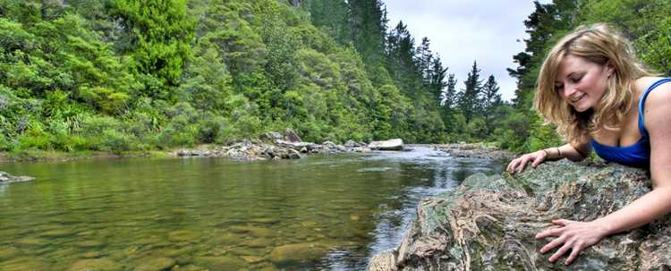
Tairua Heritage
Walk
This short walk, which starts and finishes at the
information centre, takes you through some of the historic sites in the old part of Tairua. The
route sees you cross the inlet, go round the wharf, up the hill to a lookout, before returning.
Directions: Start
at the information centre, Cross the road and head towards the bridge over Pepe Stream. The
original bridge at this point was built as a footbridge in 1911 there was another footbridge in
1942.
Prior to 1911 there was another
footbridge, known as the 1000ft bridge that ran from just inside the inlet to a point of the far
side, where the track form Whitianga came down from the hills. Extensive logging was carried out
in the hills behind the inlet just after the turn of the century an a tramway as built right
across the inlet to a point near where the present motel/restaurant is, to carry logs to the
harbour. There was also a hotel built about 1890, on a point just inside the inlet of the
southern side.
Once over the bridge, head to the left, round the
side of the hall, to a path at the rear. The hall built in 1933, has been added to and
refurbished over the years. The original hall forms its central core.
Follow the path on the edge of the
harbour to the wharf. This structure was extensively repaired in 1940 to recondition the one
build in 1930, which had been built to replace the one build it 1919. the remains of these can
be seen in the mud near high tide level, just to the right of the present wharf. A bit further
along is the boiler from the dairy factory that was once sited in this area.
 There were two sawmills in this area, situated
right on the edge of the shore. The first was built in 1864 and the second in 1878.
There were two sawmills in this area, situated
right on the edge of the shore. The first was built in 1864 and the second in 1878.
Continue on up Wharf Road and head
to the right toward the main road, The area on your left is the site of the original motor camp,
dating back to 1938. The old building here, and the one on the corner, date back to the
1940’s. the corner building was once a store and a focal point for the area.
If you stand on the corner facing the main road and
look across the road to the left you will see an old house at number 147. this was the old
school house, built for the teacher in 1879. The mill owners set up the school, which was once
alongside. Staying on the main road, head right to the old cemetery. Although people were buried
here from the late 1860’s, official records didn’t start until 1876. The last
burials here were in the early 1950’s.
 Now you head up to the top of what the early
settlers called Flagstaff Hill. It got its name form the cross-armed flagstaff that was erected
there to signal passing ships, when the mail had freight or passengers to be picked up. To get
there, walk up the concrete driveway and steps to the left of the cemetery. Turn sharp left at
the top and continue on behind the houses to a set of steep steps on your right. These will
bring you out onto a cul-de-sac. Walk out to the intersectionand turn right, then right again
into Ridge Road. Walk up this road toward the cul-de-sac at the crest of the hill, where on the
right hand side, beside number 17, is a grassy strip that runs between houses, marked by a white
walkway marker. This takes you out to the Gazebo Lookout. From here you get great views of the
harbour and Paku, the township and, to the rear, Slipper Island and Mt Pauanui.
Now you head up to the top of what the early
settlers called Flagstaff Hill. It got its name form the cross-armed flagstaff that was erected
there to signal passing ships, when the mail had freight or passengers to be picked up. To get
there, walk up the concrete driveway and steps to the left of the cemetery. Turn sharp left at
the top and continue on behind the houses to a set of steep steps on your right. These will
bring you out onto a cul-de-sac. Walk out to the intersectionand turn right, then right again
into Ridge Road. Walk up this road toward the cul-de-sac at the crest of the hill, where on the
right hand side, beside number 17, is a grassy strip that runs between houses, marked by a white
walkway marker. This takes you out to the Gazebo Lookout. From here you get great views of the
harbour and Paku, the township and, to the rear, Slipper Island and Mt Pauanui.
Return back out to the road an turn
right down the concrete drive way between the houses. Enjoy the views over the Pepe Inlet form
here. Continue on behind the houses to the end of the driveway to a set of steps tucked into the
right. Follow these down to the main road and head left back tot he bridge, only 100m away.
Time: 40 minutes
return
(Text
courtesy of “Inch by Inch – Guide to Tairua / Pauanui”)
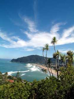
Mount Paku 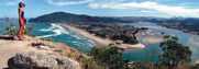
A relatively short walk and visitors will
be rewarded with spectacular 360-degree views.
Displays are placed at the summit identifying
parts of the panorama and rich history of
the area.
Directions: From Tairua town centre follow Manaia
Road,
turn right into Paku Drive, and then right
into Tirinui Crescent. The start of the track
is signposted from the end of the crescent.
Time: 30-45 minutes
return
Note: Steep last
10-15 metres
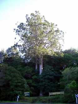
Twin Kauri Scenic Reserve
On the right hand side (heading north) on the main road
north of Tairua are two stunning Kauri trees standing side by side. These two Kauri trees, known
as the Twin Kauri’s, are easily accessible and well worth the photo opportunity. There is
a small walk from the Twin Kauri’s, which will take you to a smaller plantation of kauri
trees and other natives.
 Directions: Approximately 10 minutes drive north out of Tairua on
SH25. Situated on the right side of the road the Twin Kauri’s mark the start of the track.
Please check the track conditions at the Tairua Information Centre; this track is not always
open. You can however see the Twin Kauri trees from the road.
Directions: Approximately 10 minutes drive north out of Tairua on
SH25. Situated on the right side of the road the Twin Kauri’s mark the start of the track.
Please check the track conditions at the Tairua Information Centre; this track is not always
open. You can however see the Twin Kauri trees from the road.
Time:
30 minutes return
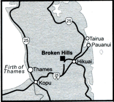
Broken Hills
19kms
south of Tairua at Hikuai is a turnoff to the right that takes visitors to a Department of
Conservation area called Broken Hills, part of the Puketui Valley. Broken Hills has a number
of walking tracks of varying lengths in beautiful New Zealand bush.
Broken Hills was formerly a thriving
goldfield in the early 1900s. There are relics of the gold mining past still in evidence, and
these are easily accessible via a network of walking tracks in the area. It was also logged for
kauri and only a few patches of unmodified forest remains today. The regenerating forest
includes Towai, Manuka, Rewarewa, Fivefinger and Totara.
Directions:
Visitors can access Broken Hills via Morrisons Road, which starts from opposite the Pauanui
turnoff at Prescotts Mobil service station, (19km south of Tairua and 27km north of Whangamata).
After 1km, just before crossing the Tairua River, turn left onto Puketui Road, Broken Hills is
6km along the unsealed road.
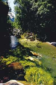
The beautiful river gorge setting
provides many opportunities for walking, swimming, canoeing, trout fishing, fossicking, rafting,
bird watching, photography, picnicking and camping. Most tracks at Broken Hills are gravel but
well formed. Maps of the tracks are placed around the area as a guide. Guided walking in the area is
available.
Tip: The Department of Conservation
has maps of the walks available in the Broken Hill area. To find these guides visit an
information centre on arrival into the Coromandel area.
Gem of the
Boom Creek Walk
This walks takes you through the site of an old
mining village. Little is left except an old jail, which is well worth a visit, check the walls
and roof for those that make this their home.
Directions: 300m before the Bridge
Carpark, the track is signposted on the left.
Time: 30 minutes return
Broken Hill
Battery Walk
This track follows the
old tramway that transported the unprocessed ore in the late 1800’s. Taking you to the
Broken Hills Mine, which was in operation form 1896 to 1914.
The rusting ironmongery seen on the
path was once the blacksmith’s shop.
Directions: Access is to the left
of the Bridge Carpark. Alternatively you can take the track to the right at the beginning of the
Gem of the Boom Creek Walk.
Time: 20 minutes Return
 previous page
  back to home page